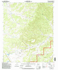
1995 Map of Third Canyon
USGS Topo · Published 1998About this map
McPhaul Ranch sits at the heart of this high-altitude landscape in New Mexico, where the remote terrain of the Cibola National Forest is defined by a network of deep canyons and seasonal water sources. The map reveals the critical importance of water management for local ranching, documenting numerous engineered features such as Lobo Well, Mae Well, and the Freeland Arroyo Tank. The topographic complexity is marked by the prominent Third Canyon Mesa, which rises above a series of drainages including Alamocita Creek and Harrington Canyon. Evidence of land use and small-scale exploration appears in several prospect sites and a remote landing strip near the ranch. From the north-flowing Rio Salado to the isolated Trinchera Lake, the map traces the essential infrastructure of a working desert landscape, including named landmarks like the Swingle Windmill and Goat Tank.
Find a feature on this map
75 named features on this map. Tap any name to fly to it.
Don’t see what you’re looking for? This feature index may not catch every label — zoom into the map to look around manually.
Map Details
Editions of this 1995 Third Canyon Map
This is the sole edition of this map. No revisions or reprints were ever made.
Other maps of this area

1917 · Broom Mountain
USGS Topo · 1:125,000

1954 · Saint Johns
USGS Topo · 1:250,000

1954 · Socorro
USGS Topo · 1:250,000

1957 · Saint Johns
USGS Topo · 1:250,000

1958 · Socorro
USGS Topo · 1:250,000

1958 · Saint Johns
USGS Topo · 1:250,000

1962 · Socorro
USGS Topo · 1:250,000

1962 · Saint Johns
USGS Topo · 1:250,000

1963 · Cal Ship Mesa
USGS Topo · 1:24,000

1964 · Third Canyon
USGS Topo · 1:24,000