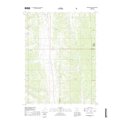
2019 Map of Thirteenmile Creek
USGS Topo · Published 2019About this map
White River National Forest lands dominate the northeastern corner of this Garfield County quadrangle, where the terrain is defined by the striking geology of the Grand Hogback. This prominent ridge serves as a geographical anchor, while high points like Big Mtn and Fourteenmile Ridge provide a vertical framework for the complex network of drainages below. The map captures a landscape shaped by water and elevation, with Piceance Creek and its many tributaries, including Thirteenmile Cr and Fourteenmile Cr, carving deep paths through the high country. Human passage is limited to specific corridors such as Thirteen Mile Creek Rd and Co Rd 13, reflecting a region where topography dictates the flow of travel. Smaller named features like Turkey Canyon, Davis Gulch, and Moonlight Gulch suggest a history of local land use and grazing in these remote western Colorado draws.
Find a feature on this map
32 named features on this map. Tap any name to fly to it.
Don’t see what you’re looking for? This feature index may not catch every label — zoom into the map to look around manually.
Map Details
Editions of this 2019 Thirteenmile Creek Map
This is the sole edition of this map. No revisions or reprints were ever made.
Other maps of this area

1906 · Grand Hogback
USGS Topo · 1:125,000

1910 · Grand Hogback
USGS Topo · 1:125,000

1925 · Parachute Creek
USGS Topo · 1:62,500

1927 · Parachute Creek
USGS Topo · 1:62,500

1952 · Rio Blanco
USGS Topo · 1:24,000

1952 · Horse Mountain
USGS Topo · 1:24,000

1952 · No Name Ridge
USGS Topo · 1:24,000

1952 · Segar Mountain
USGS Topo · 1:24,000

1956 · Grand Junction
USGS Topo · 1:250,000

1957 · Leadville
USGS Topo · 1:250,000