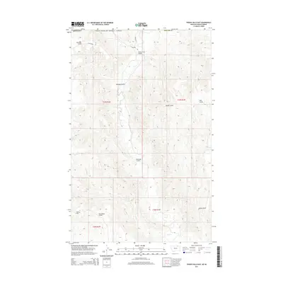
2014 Map of Thoeny Hills East
USGS Topo · Published 2014About this map
Thoeny Hills and the rugged northern drainage of the Big Dry Creek basin define this high-plains landscape along the international border in Phillips County. The terrain is deeply incised by a network of drainage features known locally as coulees, which channel seasonal runoff from the Montana uplands toward the south. Notable geographic landmarks include the appropriately named Turkey Track Coulee and Dead Horse Coulee, names that suggest the historic ranching and livestock history of this borderland region. In the northern reaches, the map records the proximity of the United States and Canada border, an area where the transition from the rolling hills to the prairie floor is marked by ephemeral waterways like Steelman Coulee and Sand Cr. Remote ranch roads such as N Frenchman Rd provide the only significant infrastructure through this sparsely populated territory.
Find a feature on this map
18 named features on this map. Tap any name to fly to it.
Don’t see what you’re looking for? This feature index may not catch every label — zoom into the map to look around manually.
Map Details
Editions of this 2014 Thoeny Hills East Map
This is the sole edition of this map. No revisions or reprints were ever made.
Other maps of this area

1954 · Glasgow
USGS Topo · 1:250,000

1957 · Glasgow
USGS Topo · 1:250,000

1958 · Glasgow
USGS Topo · 1:250,000

1984 · Thoeny Hills East
USGS Topo · 1:24,000

1984 · Coulter Coulee
USGS Topo · 1:24,000

1984 · Dead Horse Coulee
USGS Topo · 1:24,000

1984 · Crow Creek Dam
USGS Topo · 1:24,000
1984 · Thoeny Hills West
USGS Topo · 1:24,000
1984 · Salsbery Reservoir
USGS Topo · 1:24,000
2011 · Thoeny Hills West
USGS Topo · 1:24,000