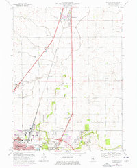
1970 Map of Thomasboro
USGS Topo · Published 1976About this map
Thomasboro and the surrounding farmland of Champaign County appear here during a period of infrastructure expansion in the mid-1970s. This agricultural landscape is defined by its rectilinear grid and the Illinois Central rail line that runs parallel to the primary highway, connecting the smaller grain elevators of Leverett to the larger markets. The map reveals the shifting character of the region as suburban developments begin to press north from the more densely settled areas. Notable features include the detailed layout of local drainage systems and the emerging network of secondary roads that support the local farming economy. These details provide a clear picture of Central Illinois during a time of transition between traditional rail-based transport and modern highway reliance.
Find a feature on this map
2 named features on this map. Tap any name to fly to it.
Don’t see what you’re looking for? This feature index may not catch every label — zoom into the map to look around manually.
Map Details
Editions of this 1970 Thomasboro Map
3 editions found
Other maps of this area

1906 · Urbana
USGS Topo · 1:62,500

1907 · Mahomet
USGS Topo · 1:62,500

1924 · Paxton
USGS Topo · 1:62,500

1927 · Paxton
USGS Topo · 1:62,500

1928 · Gibson City
USGS Topo · 1:62,500

1949 · Paxton
USGS Topo · 1:62,500

1957 · Urbana
USGS Topo · 1:62,500

1957 · Paxton
USGS Topo · 1:62,500

1957 · Gibson City
USGS Topo · 1:62,500

1957 · Urbana
USGS Topo · 1:24,000