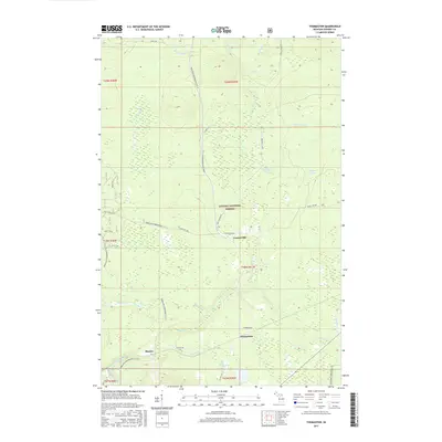
2017 Map of Thomaston
USGS Topo · Published 2017About this map
Thomaston and the surrounding timberlands of the Ottawa National Forest define this corner of Gogebic County during the mid-2010s. The landscape is characterized by a dense network of watercourses, including the Black River and smaller tributaries like Jackson Creek and Spikehorn Cr. The map captures the quiet transition of former lumbering outposts into a recreational landscape, evidenced by the extensive trail systems of the Bergland Snowmobile #11 N and Bessemer Snowmobile #8. Smaller settlements like Connorville and Planter sit along the corridors of Co Hwy 519 and Kronberg Rd, while the uniquely named Root Beer Falls on Planter Cr provides a specific point of interest in the forest. The topography is marked by numerous creeks and ponds, such as Copper Pond, which illustrate the complex drainage patterns of Michigan's western Upper Peninsula.
Find a feature on this map
37 named features on this map. Tap any name to fly to it.
Don’t see what you’re looking for? This feature index may not catch every label — zoom into the map to look around manually.
Map Details
Editions of this 2017 Thomaston Map
This is the sole edition of this map. No revisions or reprints were ever made.
Other maps of this area

1943 · Ironwood
USGS Topo · 1:48,000

1953 · Ashland
USGS Topo · 1:250,000

1955 · Bessemer
USGS Topo · 1:24,000

1955 · Wakefield
USGS Topo · 1:24,000

1955 · Wakefield
USGS Topo · 1:62,500

1955 · Wakefield NE
USGS Topo · 1:24,000

1955 · Ironwood
USGS Topo · 1:62,500

1956 · North Ironwood
USGS Topo · 1:62,500

1956 · Thomaston
USGS Topo · 1:62,500

1958 · Ashland
USGS Topo · 1:250,000