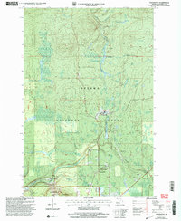
1999 Map of Thomaston
USGS Topo · Published 2004About this map
Thomaston and Connorville serve as central hubs in this landscape within the Wakefield portion of the Ottawa National Forest. The map documents a territory defined by timber management and recreational transitions at the turn of the millennium, particularly around the Indianhead Mountain Ski Area and Indianhead Mtn. A network of watercourses, including Abitosse Creek, Bernadine Creek, and the cascading Gabbro Falls, carve through the terrain, illustrating the drainage patterns that feed into Jackson Creek. Cultural landmarks such as Manley Siding on the rail line and the Bessemer Ranger District office highlight the region's historical reliance on forestry and transport. The prevalence of active sites like Gravel Pits and a Landfill near Planter Creek indicates the ongoing industrial and municipal utility of the land during the late 1990s.
Find a feature on this map
30 named features on this map. Tap any name to fly to it.
Don’t see what you’re looking for? This feature index may not catch every label — zoom into the map to look around manually.
Map Details
Editions of this 1999 Thomaston Map
This is the sole edition of this map. No revisions or reprints were ever made.
Other maps of this area

1943 · Ironwood
USGS Topo · 1:48,000

1953 · Ashland
USGS Topo · 1:250,000

1955 · Bessemer
USGS Topo · 1:24,000

1955 · Wakefield
USGS Topo · 1:24,000

1955 · Wakefield
USGS Topo · 1:62,500

1955 · Wakefield NE
USGS Topo · 1:24,000

1955 · Ironwood
USGS Topo · 1:62,500

1956 · North Ironwood
USGS Topo · 1:62,500

1956 · Thomaston
USGS Topo · 1:62,500

1958 · Ashland
USGS Topo · 1:250,000