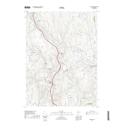
2018 Map of Thomaston
USGS Topo · Published 2018About this map
The Naugatuck River carves a deep industrial and transit corridor through this section of Connecticut, anchoring the communities of Thomaston and Plymouth. This 2018 survey documents a landscape where high-relief terrain like Hickory Hill and Pine Hill hem in the developed valleys, forcing infrastructure into tight alignments. Genealogists will find a high density of burial sites including Hillside Cem, Saint Thomas Cem, and Plymouth Hill West Side Cem. The map illustrates a complex water management system, from the large Hancock Brook Lake and Lake Plymouth to numerous smaller impoundments like Meyers Pond and Todd Hollow Brook. Notable transportation and utility features include the Terryville Tunnel and the Waterbury Airport, while the settlement at Reynolds Bridge marks a historic crossing point south of the main town centers.
Find a feature on this map
212 named features on this map. Tap any name to fly to it.
Don’t see what you’re looking for? This feature index may not catch every label — zoom into the map to look around manually.
Map Details
Editions of this 2018 Thomaston Map
This is the sole edition of this map. No revisions or reprints were ever made.
Other maps of this area

1892 · Winsted
USGS Topo · 1:62,500

1892 · Meriden
USGS Topo · 1:62,500

1892 · Granby
USGS Topo · 1:62,500

1893 · Waterbury
USGS Topo · 1:62,500

1893 · Meriden
USGS Topo · 1:62,500

1904 · Waterbury
USGS Topo · 1:62,500

1904 · Litchfield
USGS Topo · 1:125,000

1906 · Farmington
USGS Topo · 1:125,000
1946 · Southington
USGS Topo · 1:31,680

1946 · Bristol
USGS Topo · 1:31,680