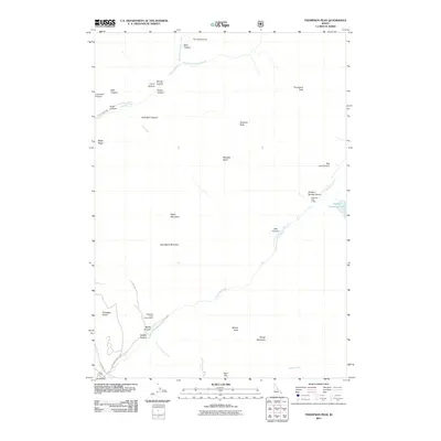
2011 Map of Thompson Peak
USGS Topo · Published 2011About this map
Thompson Peak and Atkinson Peak anchor the high elevations of this Bonneville County landscape, where the drainage of Rainey Creek and its many tributaries carve a network of canyons including Dry Elk Canyon and Bear Canyon. The map reveals a transition from these steep peaks down to the Palisades Bench near the Snake River corridor. Recreational and seasonal access is central to the area's modern character, evidenced by the Palisades Creek Campground and the Palisades Lake Lodge located near the eastern boundary. Further into the interior, the terrain opens into high-altitude features like Paradise Basin and Deer Flat, while water bodies such as Upper Palisades Lake are fed by the winding course of Palisades Creek. This survey captures the topographical complexity of the Caribou-Targhee region, showing the convergence of numerous canyons like Butler Canyon and Canary Canyon into the lower valleys.
Find a feature on this map
37 named features on this map. Tap any name to fly to it.
Don’t see what you’re looking for? This feature index may not catch every label — zoom into the map to look around manually.
Map Details
Editions of this 2011 Thompson Peak Map
This is the sole edition of this map. No revisions or reprints were ever made.
Other maps of this area

1932 · Irwin
USGS Topo · 1:96,000

1935 · Irwin
USGS Topo · 1:125,000

1943 · Driggs
USGS Topo · 1:62,500

1943 · Garns Mtn
USGS Topo · 1:62,500

1946 · Driggs
USGS Topo · 1:62,500

1946 · Garns Mtn
USGS Topo · 1:62,500

1955 · Driggs
USGS Topo · 1:250,000

1958 · Driggs
USGS Topo · 1:250,000

1962 · Driggs
USGS Topo · 1:250,000
1966 · Palisades Peak
USGS Topo · 1:24,000