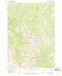
1966 Map of Palisades Peak
USGS Topo · Published 1969About this map
Palisades Peak dominates the high-elevation landscape of the Snake River Range along the Idaho-Wyoming border. This mid-1960s survey captures a transition zone between the Targhee National Forest and Teton National Forest, where the terrain is defined by a dense network of canyons and drainage systems. A primary Pack Trail system provides the only human infrastructure through areas like Waterfall Canyon, Dead Man Canyon, and Vacation Canyon. Notable natural features such as the Ice Cave and Upper Palisades Lake are documented alongside specialized topography like Neeley Cove and Siddoway Fork. The map provides an intricate look at the hydrology of the region before significant modern development, following the Snake River through its northern reaches near Mosquito Pass.
Find a feature on this map
34 named features on this map. Tap any name to fly to it.
Don’t see what you’re looking for? This feature index may not catch every label — zoom into the map to look around manually.
Map Details
Editions of this 1966 Palisades Peak Map
4 editions found
Other maps of this area

1899 · Grand Teton
USGS Topo · 1:125,000

1901 · Grand Teton
USGS Topo · 1:125,000

1931 · Jackson
USGS Topo · 1:125,000

1932 · Irwin
USGS Topo · 1:96,000

1935 · Irwin
USGS Topo · 1:125,000

1935 · Jackson
USGS Topo · 1:125,000

1943 · Driggs
USGS Topo · 1:62,500

1946 · Driggs
USGS Topo · 1:62,500

1955 · Driggs
USGS Topo · 1:250,000

1958 · Driggs
USGS Topo · 1:250,000