
1987 Map of Thompson Point
USGS Topo · Published 1987About this map
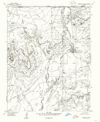
The Vermilion Cliffs and Shinarump Cliffs dominate this 1987 borderland survey between Kane Co, Utah, and Coconino Co, Arizona. The landscape is defined by massive plateau features like Wygaret Terrace and John R Flat, separated by a complex network of drainages including Hog Canyon and Johnson Wash. A network of 4WD trails provides the only transit through this high-desert terrain, connecting seasonal water sources like Sheep Springs, Willis Spring, and Ram Spring. Evidence of high-altitude industry is present near the southern edge of the sheet, where Open Pit Mines are situated within Eightmile Gap. Notable topographic landmarks such as Thompson Point and Savage Point overlook deep canyons and coves, illustrating the stark erosion patterns characteristic of the Colorado Plateau.
Find a feature on this map
30 named features on this map. Tap any name to fly to it.
Don’t see what you’re looking for? This feature index may not catch every label — zoom into the map to look around manually.
Map Details
Editions of this 1987 Thompson Point Map
This is the sole edition of this map. No revisions or reprints were ever made.
Other maps of this area

1886 · Kanab
USGS Topo · 1:250,000

1886 · Kaibab
USGS Topo · 1:250,000

1953 · Cedar City
USGS Topo · 1:250,000

1953 · Grand Canyon
USGS Topo · 1:250,000

1954 · Johnson SE
USGS Topo · 1:24,000

1954 · Johnson NE
USGS Topo · 1:24,000

1954 · Kanab SE
USGS Topo · 1:24,000

1954 · Shinarump NW
USGS Topo · 1:24,000

1954 · Johnson SW
USGS Topo · 1:24,000
1954 · Fredonia NE
USGS Topo · 1:24,000