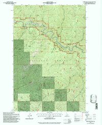
1995 Map of Thor Mountain
USGS Topo · Published 1997About this map
St Joe River carves a deep valley through this portion of the St Joe National Forest, serving as a central geographic corridor as it flows westward. The terrain is defined by steep ridges and prominent peaks, including the 1995 elevation data for Thor Mountain and the towering Adams Peak in the northeast. This landscape reveals a complex network of drainage basins, where Nugget Creek, Bluff Creek, and the West Fork feed into larger systems. Evidence of historical activity is found in names like Prospector Ridge and Nugget Hill, suggesting the area's legacy of mineral exploration. Transport is limited to a sparse network of 4wd tracks, underscoring the wilderness character of the region. Distinctive features like Hardpan Ridge and the Bluff Divide provide a clear view of the high-altitude topography that separates these watersheds.
Find a feature on this map
38 named features on this map. Tap any name to fly to it.
Don’t see what you’re looking for? This feature index may not catch every label — zoom into the map to look around manually.
Map Details
Editions of this 1995 Thor Mountain Map
This is the sole edition of this map. No revisions or reprints were ever made.
Other maps of this area

1914 · Avery
USGS Topo · 1:125,000

1917 · Avery
USGS Topo · 1:125,000

1918 · St Regis
USGS Topo · 1:125,000

1919 · St. Regis
USGS Topo · 1:125,000

1956 · Saltese
USGS Topo · 1:62,500

1956 · Wallace
USGS Topo · 1:250,000

1957 · Haugan
USGS Topo · 1:62,500

1957 · Simmons Peak
USGS Topo · 1:62,500

1960 · Wallace
USGS Topo · 1:250,000
1969 · Bathtub Mtn
USGS Topo · 1:24,000