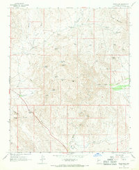
1967 Map of Thorn Peak
USGS Topo · Published 1969About this map
Santa Maria Ranch sits along the southern reaches of this landscape where the Santa Maria River cuts through the desert terrain. The late-1960s environment is defined by an intricate network of drainage systems, including Bridle Creek, Skunk Canyon, and Cottonwood Canyon, all of which emphasize the critical importance of water in this arid region. Mining interests are evident near the river, notably at the Sultan Mine and various scattered prospects.
Find a feature on this map
45 named features on this map. Tap any name to fly to it.
Don’t see what you’re looking for? This feature index may not catch every label — zoom into the map to look around manually.
Map Details
Editions of this 1967 Thorn Peak Map
2 editions found
Other maps of this area

1923 · Signal
USGS Topo · 1:250,000

1942 · Signal
USGS Topo · 1:250,000

1945 · Bagdad
USGS Topo · 1:62,500

1948 · Bagdad
USGS Topo · 1:62,500

1950 · Prescott
USGS Topo · 1:250,000

1954 · Prescott
USGS Topo · 1:250,000

1958 · Prescott
USGS Topo · 1:250,000

1959 · Prescott
USGS Topo · 1:250,000

1960 · Prescott
USGS Topo · 1:250,000

1965 · Prescott
USGS Topo · 1:250,000