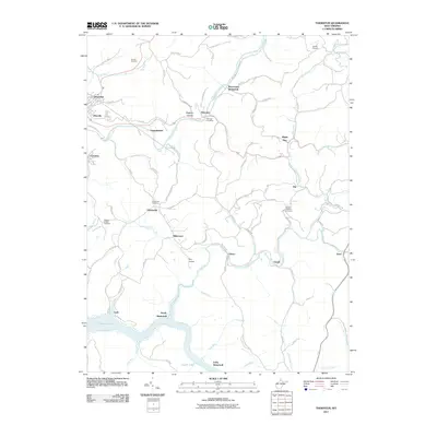
2011 Map of Thornton
USGS Topo · Published 2011About this map
Three Fork Creek and its many tributaries, such as Maple Run and Little Sandy Creek, carve through the Taylor County hills, anchoring a landscape where small settlements like Thornton and Knottsville have long endured. This 2011 survey documents the persistent rural character of the area, noting several sites of historical significance including Westerman, Sandy, and Loftis. These former communities appear alongside active landmarks such as the Thornton Post Office and Bethel Church. To the south, the waters of Tygart Lake reach into the valleys of Lick Run and Wolf Run, illustrating the managed waterways that have reshaped the region's topography. Genealogists will find a high density of burial grounds to study, including Current Cemetery, Mount Pleasant Cemetery, and the Wesley Chapel Cemetery. Transportation remains tied to the terrain, with routes like Old 50 E and the Iron Town rail line following the natural contours of the creek beds.
Find a feature on this map
79 named features on this map. Tap any name to fly to it.
Don’t see what you’re looking for? This feature index may not catch every label — zoom into the map to look around manually.
Map Details
Editions of this 2011 Thornton Map
This is the sole edition of this map. No revisions or reprints were ever made.
Other maps of this area

1886 · St. George
USGS Topo · 1:125,000

1891 · St. George
USGS Topo · 1:125,000

1902 · Fairmont
USGS Topo · 1:62,500

1904 · Philippi
USGS Topo · 1:62,500

1907 · Thornton
USGS Topo · 1:62,500

1907 · Belington
USGS Topo · 1:62,500

1923 · Fairmont
USGS Topo · 1:62,500

1925 · Philippi
USGS Topo · 1:62,500

1926 · Fairmont
USGS Topo · 1:62,500

1926 · Thornton
USGS Topo · 1:62,500