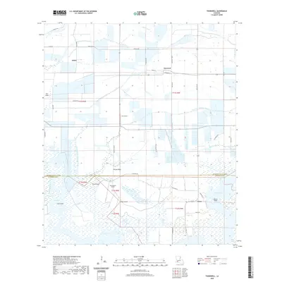
2020 Map of Thornwell
USGS Topo · Published 2020About this map
The low-lying wetlands of Jefferson Davis and Cameron Parishes are defined by an intricate network of waterways and reclaimed coastal prairie. This landscape is dominated by the expansive Lake Arthur and the winding Bayou Lacassine, where natural features like Goose Island and Biscuit Island emerge from the surrounding Willow Marsh. The human footprint in this part of Louisiana is closely tied to agricultural drainage and aviation, evidenced by the extensive Thornwell Drainage Canal and Holton and Winn Drainage Canal. Small settlements such as Thornwell, Lowry, and Niblett are connected by a grid of rural roads including Warehouse Rd and Lacassane Rd. The presence of Lyon Airport and Goose Island Airport underscores the region's reliance on aerial access for surveying or managing these vast tracts of marsh and prairie.
Find a feature on this map
46 named features on this map. Tap any name to fly to it.
Don’t see what you’re looking for? This feature index may not catch every label — zoom into the map to look around manually.
Map Details
Editions of this 2020 Thornwell Map
This is the sole edition of this map. No revisions or reprints were ever made.
Other maps of this area

1934 · Lake Misere
USGS Topo · 1:24,000

1934 · Latania Lake
USGS Topo · 1:24,000

1935 · Lake Misere
USGS Topo · 1:31,680

1935 · Latania Lake
USGS Topo · 1:31,680

1946 · Lacassine
USGS Topo · 1:31,680

1946 · Lake Arthur
USGS Topo · 1:31,680

1946 · Hayes
USGS Topo · 1:31,680

1946 · Jennings
USGS Topo · 1:31,680

1947 · Thornwell
USGS Topo · 1:31,680

1947 · Welsh
USGS Topo · 1:31,680