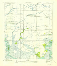
1954 Map of Thornwell
USGS Topo · Published 1954About this map
The agricultural landscape of Thornwell is defined by a dense network of irrigation and drainage infrastructure in the mid-1950s. This survey illustrates the intricate water management system necessary for rice farming or similar local agriculture, featuring the Niblett Farm Canal, Live Oak Farm Irrigation Canal, and numerous Pump House stations scattered across the grid. The Southern Pacific railroad runs east-to-west through the heart of the settlement, paralleling State Highway No 734 and facilitating the movement of goods from this coastal prairie region.
Find a feature on this map
29 named features on this map. Tap any name to fly to it.
Don’t see what you’re looking for? This feature index may not catch every label — zoom into the map to look around manually.
Map Details
Editions of this 1954 Thornwell Map
This is the sole edition of this map. No revisions or reprints were ever made.
Other maps of this area

1934 · Lake Misere
USGS Topo · 1:24,000

1934 · Latania Lake
USGS Topo · 1:24,000

1935 · Lake Misere
USGS Topo · 1:31,680

1935 · Latania Lake
USGS Topo · 1:31,680

1946 · Lacassine
USGS Topo · 1:31,680

1946 · Lake Arthur
USGS Topo · 1:31,680

1946 · Hayes
USGS Topo · 1:31,680

1946 · Jennings
USGS Topo · 1:31,680

1947 · Thornwell
USGS Topo · 1:31,680

1947 · Welsh
USGS Topo · 1:31,680