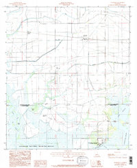
1985 Map of Thornwell
USGS Topo · Published 1985About this map
The low-lying wetlands of southern Louisiana define this 1985 survey, where the boundary between Jefferson Davis Parish and Cameron Parish meets the sprawling Lacassine National Wildlife Refuge. The landscape is a complex network of water management and industrial presence, characterized by the Thornwell Drainage Canal and the tracks of the Southwestern RR. Small settlements like Thornwell and Niblett are situated among a grid of flumes and siphons, reflecting the intensive agricultural and hydraulic engineering of the region.
Find a feature on this map
22 named features on this map. Tap any name to fly to it.
Don’t see what you’re looking for? This feature index may not catch every label — zoom into the map to look around manually.
Map Details
Editions of this 1985 Thornwell Map
This is the sole edition of this map. No revisions or reprints were ever made.
Other maps of this area

1934 · Lake Misere
USGS Topo · 1:24,000

1934 · Latania Lake
USGS Topo · 1:24,000

1935 · Lake Misere
USGS Topo · 1:31,680

1935 · Latania Lake
USGS Topo · 1:31,680

1946 · Lacassine
USGS Topo · 1:31,680

1946 · Lake Arthur
USGS Topo · 1:31,680

1946 · Hayes
USGS Topo · 1:31,680

1946 · Jennings
USGS Topo · 1:31,680

1947 · Thornwell
USGS Topo · 1:31,680

1947 · Welsh
USGS Topo · 1:31,680