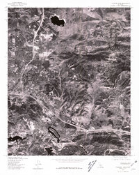
1976 Map of Thousand Oaks
USGS Topo · Published 1981About this map
Thousand Oaks appears during a period of rapid suburbanization in this 1976 orthophotoquad, where the organized patterns of residential housing tracts and commercial corridors press directly against the undeveloped terrain of the Santa Monica Mountains. The aerial imagery, captured by the Geological Survey in cooperation with the Soil Conservation Service, reveals a landscape in mid-transformation. Developed residential blocks and shopping centers define the lower elevations, while the higher ground remains marked by natural landmarks like Simi Peak. The sharp contrast between the burgeoning city and the winding drainage paths of Skeleton Canyon and Triunfo Canyon illustrates the complex geography of this region before further late-century expansion filled in the remaining open spaces.
Find a feature on this map
4 named features on this map. Tap any name to fly to it.
Don’t see what you’re looking for? This feature index may not catch every label — zoom into the map to look around manually.
Map Details
Editions of this 1976 Thousand Oaks Map
This is the sole edition of this map. No revisions or reprints were ever made.
Other maps of this area

1900 · Triunfo Pass
USGS Topo · 1:62,500

1900 · Piru
USGS Topo · 1:62,500

1903 · Calabasas
USGS Topo · 1:62,500

1903 · Camulos
USGS Topo · 1:125,000

1903 · Santa Susana
USGS Topo · 1:62,500

1921 · Piru
USGS Topo · 1:62,500

1921 · Triunfo Pass
USGS Topo · 1:62,500

1929 · Vejor
USGS Topo · 1:24,000

1932 · Seminole
USGS Topo · 1:24,000

1932 · Russell Valley
USGS Topo · 1:24,000