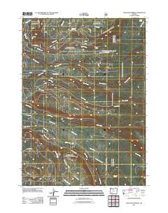
2011 Map of Thousand Springs
USGS Topo · Published 2011About this map
Thousand Springs and the surrounding network of mountain drainages define this high-elevation landscape in the southern Oregon Cascades. The 2011 survey reveals an intricate web of timber and forest service routes, including the Thousand Springs Rd and the Crater Creek Motorway Rd, which navigate the complex hydrology of the region. Numerous creeks like Castle Creek, Whisky Creek, and Union Creek descend through the terrain, punctuated by small outposts such as Sunday Camp and Wagon Camp. The map provides a look at the hydrographic profile of the area near the Crater Lake boundary, where features like Spruce Lake and Crater Springs sit amidst a heavily dissected landscape of ridges and glacial-carved valleys, illustrating the transition between high peaks and the lower forest zones.
Find a feature on this map
33 named features on this map. Tap any name to fly to it.
Don’t see what you’re looking for? This feature index may not catch every label — zoom into the map to look around manually.
Map Details
Editions of this 2011 Thousand Springs Map
This is the sole edition of this map. No revisions or reprints were ever made.
Other maps of this area

1891 · Ashland
USGS Topo · 1:250,000

1893 · Ashland
USGS Topo · 1:250,000

1897 · Ashland
USGS Topo · 1:250,000

1917 · Diamond Lake
USGS Topo · 1:125,000

1955 · Medford
USGS Topo · 1:250,000

1956 · Diamond Lake
USGS Topo · 1:62,500

1956 · Garwood Butte
USGS Topo · 1:62,500

1956 · Prospect
USGS Topo · 1:62,500

1957 · Medford
USGS Topo · 1:250,000

1958 · Medford
USGS Topo · 1:250,000