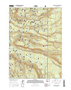
2017 Map of Thousand Springs
USGS Topo · Published 2017About this map
Crater Lake National Park and Rogue River National Forest meet in this high-altitude landscape where Douglas, Jackson, and Klamath Counties converge. The terrain is defined by its hydrology, featuring the namesake Thousand Springs and unique environments like the Sphagnum Bog near Crater Springs. A network of Forest Service roads, such as Huckleberry Rd and Union Creek Rd, provides the primary infrastructure through these heavily forested slopes. Numerous drainage systems, including Wizard Cr, Copeland Cr, and Castle Cr, carve the volcanic geography as they flow westward toward the Rogue River basin. The presence of the Crater Creek Motorway Rd and various remote tracks like Rd 805 near Spruce Lake illustrate the area's ongoing management for conservation and recreation in the southern Cascades.
Find a feature on this map
52 named features on this map. Tap any name to fly to it.
Don’t see what you’re looking for? This feature index may not catch every label — zoom into the map to look around manually.
Map Details
Editions of this 2017 Thousand Springs Map
This is the sole edition of this map. No revisions or reprints were ever made.
Other maps of this area

1891 · Ashland
USGS Topo · 1:250,000

1893 · Ashland
USGS Topo · 1:250,000

1897 · Ashland
USGS Topo · 1:250,000

1917 · Diamond Lake
USGS Topo · 1:125,000

1955 · Medford
USGS Topo · 1:250,000

1956 · Diamond Lake
USGS Topo · 1:62,500

1956 · Garwood Butte
USGS Topo · 1:62,500

1956 · Prospect
USGS Topo · 1:62,500

1957 · Medford
USGS Topo · 1:250,000

1958 · Medford
USGS Topo · 1:250,000