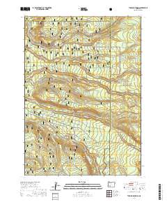
2020 Map of Thousand Springs
USGS Topo · Published 2020About this map
Rogue River National Forest and the western edge of Crater Lake National Park define this high-altitude landscape where Douglas, Jackson, and Klamath counties meet. The terrain is a network of alpine water sources and drainage systems, featuring the notable Crater Springs and the expansive Sphagnum Bog in the northeast. Waterways like Union Creek, Crater Cr, and Bybee Cr carve through the forest, while Spruce Lake sits at a higher elevation between the Crater Creek Motorway Rd and the park boundary. The map documents an extensive system of forest service roads and recreational trails, including the Thousands Springs Snomo Trail and specialized routes like the Nordic Ohv and Discovery Ohv, reflecting a modern era of backcountry management and winter access near the Rogue Wild And Scenic River.
Find a feature on this map
98 named features on this map. Tap any name to fly to it.
Don’t see what you’re looking for? This feature index may not catch every label — zoom into the map to look around manually.
Map Details
Editions of this 2020 Thousand Springs Map
This is the sole edition of this map. No revisions or reprints were ever made.
Other maps of this area

1891 · Ashland
USGS Topo · 1:250,000

1893 · Ashland
USGS Topo · 1:250,000

1897 · Ashland
USGS Topo · 1:250,000

1917 · Diamond Lake
USGS Topo · 1:125,000

1955 · Medford
USGS Topo · 1:250,000

1956 · Diamond Lake
USGS Topo · 1:62,500

1956 · Garwood Butte
USGS Topo · 1:62,500

1956 · Prospect
USGS Topo · 1:62,500

1957 · Medford
USGS Topo · 1:250,000

1958 · Medford
USGS Topo · 1:250,000