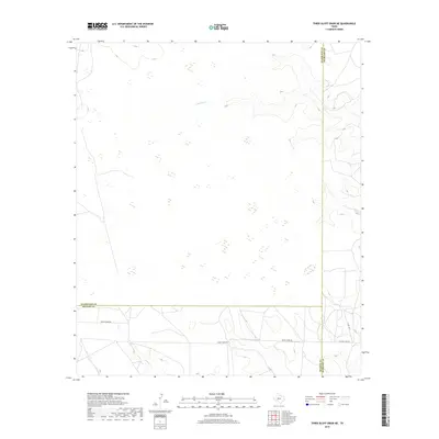
2019 Map of Three Bluff Draw NE
USGS Topo · Published 2019About this map
Sterling Cr and Indian Cr carve intermittent drainage patterns across this high plains landscape at the intersection of Glasscock, Sterling, and Reagan counties. The terrain is defined by its wide, open character, typical of the Edwards Plateau transition, where surface water is sparse and seasonal. Human presence is marked primarily by a network of ranch and utility roads, including the prominent Radio Tower Rd and the historical corridor of Old Big Lake Rd. These routes facilitate the local ranching and energy infrastructure, connecting remote points in a region where the geography is dictated by the subtle shifts in elevation that guide Gorrill Cr toward the south. The map provides a detailed view of these rural transit lines and the natural contours that have long influenced land use in this part of West Texas.
Find a feature on this map
9 named features on this map. Tap any name to fly to it.
Don’t see what you’re looking for? This feature index may not catch every label — zoom into the map to look around manually.
Map Details
Editions of this 2019 Three Bluff Draw NE Map
This is the sole edition of this map. No revisions or reprints were ever made.
Other maps of this area

1954 · San Angelo
USGS Topo · 1:250,000

1958 · San Angelo
USGS Topo · 1:250,000

1963 · Glass Ranch
USGS Topo · 1:24,000

1963 · Currie Reservoir
USGS Topo · 1:24,000

1963 · Garden City
USGS Topo · 1:24,000

1965 · San Angelo
USGS Topo · 1:250,000

1973 · Hay Hollow
USGS Topo · 1:24,000

1973 · Three Bluff Draw
USGS Topo · 1:24,000

1973 · Three Bluff Draw NE
USGS Topo · 1:24,000
1973 · Coon Dive Draw NW
USGS Topo · 1:24,000