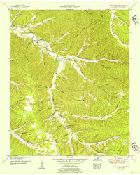
1951 Map of Three Churches
USGS Topo · Published 1954About this map
Three Churches serves as the central focal point for this rural Wayne County landscape, situated where the waters of Indian Creek meet the surrounding hills. The area is defined by a dense network of hollows, such as Ayers Hollow and Robinson Hollow, which dictate the placement of early infrastructure and homesites. Public life in the mid-20th century centered on dispersed community hubs like Cromwell Crossroads, while education was served by local institutions including Memorial School and the Masonic Hall Sch. The presence of the Natzhez Trace Parkway in the northeast corner signals the modernization of transport through this section of the Tennessee Valley, even as much of the interior remains accessible only via winding valley roads. Genealogists will find numerous family-named landmarks and burial sites, including Horton Cem and King Cem, scattered among the ridges and flats.
Find a feature on this map
47 named features on this map. Tap any name to fly to it.
Don’t see what you’re looking for? This feature index may not catch every label — zoom into the map to look around manually.
Map Details
Editions of this 1951 Three Churches Map
2 editions found
Other maps of this area

1905 · Waynesboro
USGS Topo · 1:125,000

1936 · Collinwood
USGS Topo · 1:24,000

1936 · Eagle Creek
USGS Topo · 1:24,000

1936 · Light
USGS Topo · 1:24,000

1936 · Negro Hollow
USGS Topo · 1:24,000

1936 · Cypress Inn
USGS Topo · 1:24,000

1936 · Three Churches
USGS Topo · 1:24,000

1936 · Ransom Stand
USGS Topo · 1:24,000

1936 · Waynesboro
USGS Topo · 1:24,000

1936 · Martins Mills
USGS Topo · 1:24,000