
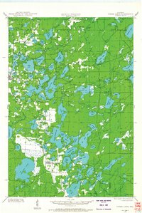
1938 Map of Three Lakes
USGS Topo · Published 1956About this map
Glacial lakes and dense woodlands dominate this 1938 survey of the lake country around Three Lakes and Eagle River. The landscape is a complex network of interconnected waterways, featuring large basins like Catfish Lake and Eagle Lake alongside smaller, secluded pools such as Scattering Rice Lake and Tinsel Lake. This era shows the region during its transition into a premier recreational destination, preserved in part by the Northern Highland State Forest.
Find a feature on this map
92 named features on this map. Tap any name to fly to it.
Don’t see what you’re looking for? This feature index may not catch every label — zoom into the map to look around manually.
Map Details
Editions of this 1938 Three Lakes Map
2 editions found
Other maps of this area

1928 · Three Lakes
USGS Topo · 1:48,000

1930 · Robbins
USGS Topo · 1:48,000

1938 · Phelps
USGS Topo · 1:48,000

1938 · Alvin
USGS Topo · 1:48,000

1938 · Robbins
USGS Topo · 1:48,000

1939 · Crandon
USGS Topo · 1:48,000

1940 · Monico
USGS Topo · 1:48,000

1940 · Rhinelander
USGS Topo · 1:48,000

1941 · Crandon
USGS Topo · 1:48,000

1945 · Three Lakes
USGS Topo · 1:48,000