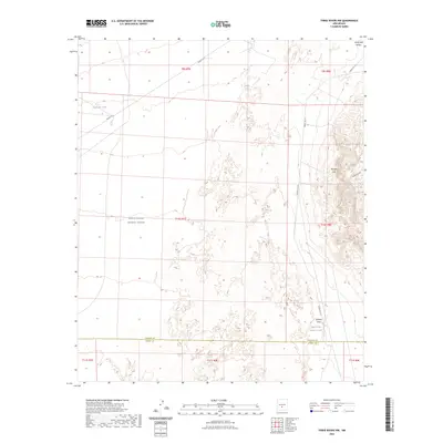
2023 Map of Three Rivers NW
USGS Topo · Published 2023About this map
White Sands Missile Range dominates the vast desert landscape of the Tularosa Basin, where military operations intersect with the natural topography of the Phillips Hills. This high-altitude desert environment is defined by its intermittent water sources and drainage patterns, including Dog-Town Tank and the Upper Steer Pasture Tank situated near the border of Lincoln and Otero counties. The presence of these named tanks and draws, such as Jackson Draw and North Mill Arroyo, highlights the historical importance of water management in a region where the land was utilized for ranching prior to and alongside federal military designation. The map provides a precise look at the township and range grid system across T9S, T10S, and T11S, showing how these administrative boundaries overlie the arroyos and hills of the New Mexico interior.
Find a feature on this map
17 named features on this map. Tap any name to fly to it.
Don’t see what you’re looking for? This feature index may not catch every label — zoom into the map to look around manually.
Map Details
Editions of this 2023 Three Rivers NW Map
This is the sole edition of this map. No revisions or reprints were ever made.
Other maps of this area

1916 · Tularosa
USGS Topo · 1:125,000

1918 · Oscura Peak
USGS Topo · 1:125,000

1947 · Three Rivers
USGS Topo · 1:62,500

1947 · Capitol Peak
USGS Topo · 1:62,500

1948 · Chihuahua Ranch
USGS Topo · 1:62,500

1948 · Mockingbird Gap
USGS Topo · 1:62,500

1950 · Three Rivers
USGS Topo · 1:24,000

1950 · Oscura
USGS Topo · 1:24,000

1954 · Tularosa
USGS Topo · 1:250,000

1958 · Tularosa
USGS Topo · 1:250,000