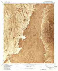
1981 Map of Three Rivers NW
USGS Topo · Published 1982About this map
The Malpais dominates this landscape, showing the stark intersection of volcanic geology and mid-century military infrastructure. This orthophotomap, based on early 1970s aerial photography, reveals the dark, irregular texture of Lava flows as they spill across the basin toward the Phillips Hills. The vast majority of the terrain falls within the White Sands Missile Range, a restricted area where remote technical installations like the Oscura Range Center and the D B Site Radio Tower were established far from civilian settlements.
Find a feature on this map
16 named features on this map. Tap any name to fly to it.
Don’t see what you’re looking for? This feature index may not catch every label — zoom into the map to look around manually.
Map Details
Editions of this 1981 Three Rivers NW Map
This is the sole edition of this map. No revisions or reprints were ever made.
Other maps of this area

1916 · Tularosa
USGS Topo · 1:125,000

1918 · Oscura Peak
USGS Topo · 1:125,000

1947 · Three Rivers
USGS Topo · 1:62,500

1947 · Capitol Peak
USGS Topo · 1:62,500

1948 · Chihuahua Ranch
USGS Topo · 1:62,500

1948 · Mockingbird Gap
USGS Topo · 1:62,500

1950 · Three Rivers
USGS Topo · 1:24,000

1950 · Oscura
USGS Topo · 1:24,000

1954 · Tularosa
USGS Topo · 1:250,000

1958 · Tularosa
USGS Topo · 1:250,000