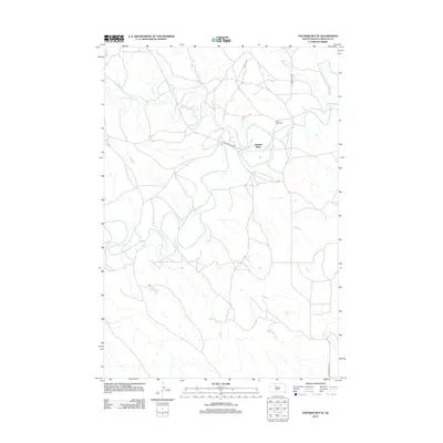
2012 Map of Thunder Butte
USGS Topo · Published 2012About this map
The prominent landform of Thunder Butte rises above the plains of Ziebach County, anchoring a landscape shaped by the winding course of the Moreau River. This modern topographic survey illustrates the rural settlement patterns along the river valley, where the small community of Thunder Butte is situated near the junction of several drainage systems. Local history is marked by the presence of Saint Luke Cem on a plateau overlooking the river, providing a genealogical reference point for families in this part of South Dakota. The drainage network is complex, with Thunder Butte Cr, Beaver Trap Cr, and Sophia Cr feeding into the main river channel. Local transit relies on a network of unpaved routes like Leedom Pike Rd and Thunder Butte Rd, which trace the section lines and natural contours of the northern plains.
Find a feature on this map
10 named features on this map. Tap any name to fly to it.
Don’t see what you’re looking for? This feature index may not catch every label — zoom into the map to look around manually.
Map Details
Editions of this 2012 Thunder Butte Map
This is the sole edition of this map. No revisions or reprints were ever made.
Other maps of this area

1951 · Redelm NE
USGS Topo · 1:24,000

1951 · Dupree NE
USGS Topo · 1:24,000

1951 · Thunder Butte
USGS Topo · 1:24,000

1953 · McIntosh
USGS Topo · 1:250,000

1958 · McIntosh
USGS Topo · 1:250,000

1979 · Dupree
USGS Topo · 1:25,000

1982 · Irish Creek SW
USGS Topo · 1:24,000
1982 · Red Elm
USGS Topo · 1:24,000

1982 · Glad Valley SE
USGS Topo · 1:24,000
1982 · Irish Creek SE
USGS Topo · 1:24,000