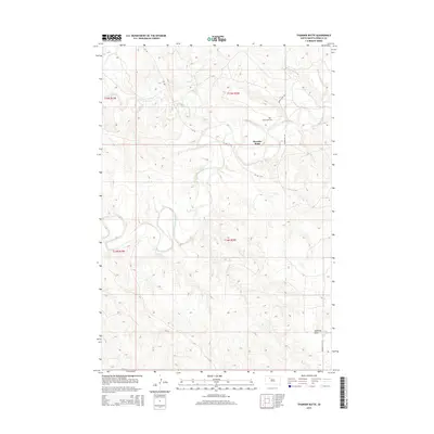
2015 Map of Thunder Butte
USGS Topo · Published 2015About this map
The landmark of Thunder Butte rises prominently above the surrounding plains of Ziebach County, serving as a focal point for the small settlement that shares its name. The drainage pattern of the Moreau River dominates the central landscape, fed by several watercourses including Thunder Butte Cr and Beaver Trap Cr. This area represents a quiet segment of the South Dakota prairie where the human footprint is defined by a sparse network of county roads and a few enduring markers of local history. Saint Luke Cem stands as one of the few named community sites, while the intersection of Thunder Butte Rd and Leedom Pike Rd provides the primary access through this rangeland. The presence of Sophia Cr in the north and the Sandrock Draw to the southeast illustrates the complex topography of this river valley.
Find a feature on this map
15 named features on this map. Tap any name to fly to it.
Don’t see what you’re looking for? This feature index may not catch every label — zoom into the map to look around manually.
Map Details
Editions of this 2015 Thunder Butte Map
This is the sole edition of this map. No revisions or reprints were ever made.
Other maps of this area

1951 · Redelm NE
USGS Topo · 1:24,000

1951 · Dupree NE
USGS Topo · 1:24,000

1951 · Thunder Butte
USGS Topo · 1:24,000

1953 · McIntosh
USGS Topo · 1:250,000

1958 · McIntosh
USGS Topo · 1:250,000

1979 · Dupree
USGS Topo · 1:25,000

1982 · Irish Creek SW
USGS Topo · 1:24,000
1982 · Red Elm
USGS Topo · 1:24,000

1982 · Glad Valley SE
USGS Topo · 1:24,000
1982 · Irish Creek SE
USGS Topo · 1:24,000