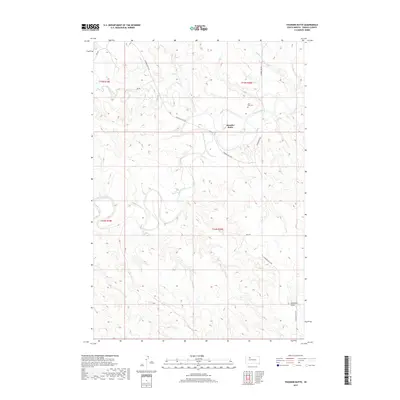
2017 Map of Thunder Butte
USGS Topo · Published 2017About this map
The Moreau River meanders across this Ziebach County landscape, carving a wide valley floor flanked by the distinct upland prominence of Thunder Butte. This 2017 survey by the U.S. Geological Survey captures the rural character of the region, where wide-reaching drainage systems like Thunder Butte Cr, Sophia Cr, and Beaver Trap Cr define the movement of water through the prairie. Near a sharp bend in the river, Saint Luke Cem stands as a primary landmark for local history and genealogy, situated just north of the junction between Leedon Pike Rd and Thunder Butte Rd. The map illustrates a network of section-line roads and tracks, including Ree's Rd, that provide access to the remote terrain leading toward Sandrock Draw in the southeast.
Find a feature on this map
16 named features on this map. Tap any name to fly to it.
Don’t see what you’re looking for? This feature index may not catch every label — zoom into the map to look around manually.
Map Details
Editions of this 2017 Thunder Butte Map
This is the sole edition of this map. No revisions or reprints were ever made.
Other maps of this area

1951 · Redelm NE
USGS Topo · 1:24,000

1951 · Dupree NE
USGS Topo · 1:24,000

1951 · Thunder Butte
USGS Topo · 1:24,000

1953 · McIntosh
USGS Topo · 1:250,000

1958 · McIntosh
USGS Topo · 1:250,000

1979 · Dupree
USGS Topo · 1:25,000

1982 · Irish Creek SW
USGS Topo · 1:24,000
1982 · Red Elm
USGS Topo · 1:24,000

1982 · Glad Valley SE
USGS Topo · 1:24,000
1982 · Irish Creek SE
USGS Topo · 1:24,000