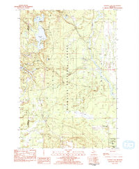
1983 Map of Thunder Lake
USGS Topo · Published 1984About this map
Hiawatha National Forest dominates this landscape in Michigan's Upper Peninsula, where the border of Delta Co and Schoolcraft Co cuts through a dense network of glacial lakes and wetlands. The area is defined by the Indian River and its numerous tributaries, including Star Creek and Little Murphy Creek, which drain the low-lying timberlands. For researchers of local industry, Richardsons Mill sits near the river in the southeastern portion of the quadrangle, while a Gravel Pit further south indicates the region's extraction history.
Find a feature on this map
25 named features on this map. Tap any name to fly to it.
Don’t see what you’re looking for? This feature index may not catch every label — zoom into the map to look around manually.
Map Details
Editions of this 1983 Thunder Lake Map
This is the sole edition of this map. No revisions or reprints were ever made.
Other maps of this area

1931 · Cooks NE
USGS Topo · 1:31,680

1931 · Steuben SE
USGS Topo · 1:31,680

1931 · Steuben SW
USGS Topo · 1:31,680

1931 · Steuben NE
USGS Topo · 1:31,680

1931 · Cooks NW
USGS Topo · 1:31,680

1931 · Steuben NW
USGS Topo · 1:31,680

1931 · Skeels Lake NE
USGS Topo · 1:31,680

1932 · Skeels Lake SE
USGS Topo · 1:31,680

1932 · Garden NE
USGS Topo · 1:31,680

1954 · Escanaba
USGS Topo · 1:250,000