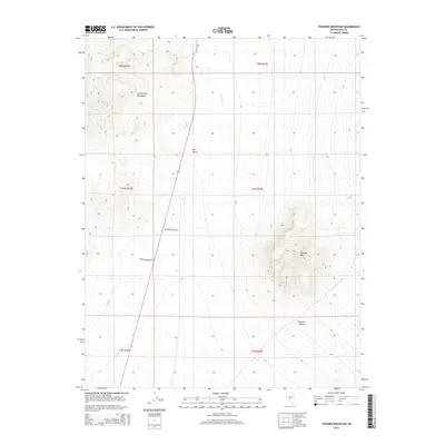
2014 Map of Thunder Mountain
USGS Topo · Published 2014About this map
San Antonio Mountains dominate the western portion of this Nye County landscape, overlooking a desert basin where the small settlement of Rye Patch sits along State Route 376. The terrain transitions from these high peaks down toward the Ralston Desert in the southeast, a topography defined by significant elevation changes. Centered in the quadrangle is the prominent landmark of Thunder Mtn, which rises above the surrounding flats and provides a clear geographic anchor for the region. Man-made infrastructure is sparse but notable, with Sportsman Park Rd and Conservation Camp Rd cutting across the desert floor. These roads, combined with the presence of Hunts Cr, suggest a land used for seasonal access and resource management rather than dense habitation.
Find a feature on this map
14 named features on this map. Tap any name to fly to it.
Don’t see what you’re looking for? This feature index may not catch every label — zoom into the map to look around manually.
Map Details
Editions of this 2014 Thunder Mountain Map
This is the sole edition of this map. No revisions or reprints were ever made.
Other maps of this area

1907 · Tonopah
USGS Topo · 1:250,000

1908 · Tonopah
USGS Topo · 1:250,000

1956 · Tonopah
USGS Topo · 1:250,000

1959 · Tonopah
USGS Topo · 1:250,000
1960 · Tonopah
USGS Topo · 1:24,000

1961 · Tonopah
USGS Topo · 1:62,500

1962 · Tonopah
USGS Topo · 1:250,000

1963 · Baxter Spring
USGS Topo · 1:62,500

1971 · Antelope Spring
USGS Topo · 1:24,000
1986 · Hannapah
USGS Topo · 1:24,000