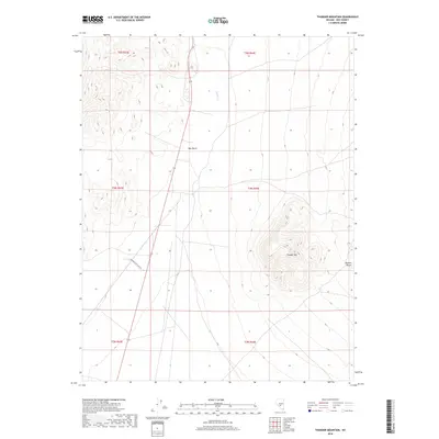
2018 Map of Thunder Mountain
USGS Topo · Published 2018About this map
Thunder Mountain dominates the central-eastern topography of this Nye County landscape, rising sharply above the surrounding high desert terrain. The area is characterized by the arid expanse of the Ralston Desert and the subtle drainage of Hunts Creek to the north. Settlement is sparse, represented by the locale at Rye Patch, which sits at the intersection of local transportation routes and the desert floor. The presence of Conservation Camp Road suggests a specific land use and infrastructure pattern tied to the mid-20th-century development of this region. This USGS survey provides a detailed record of the township and range boundaries that define property and land management across this portion of the Great Basin.
Find a feature on this map
11 named features on this map. Tap any name to fly to it.
Don’t see what you’re looking for? This feature index may not catch every label — zoom into the map to look around manually.
Map Details
Editions of this 2018 Thunder Mountain Map
This is the sole edition of this map. No revisions or reprints were ever made.
Other maps of this area

1907 · Tonopah
USGS Topo · 1:250,000

1908 · Tonopah
USGS Topo · 1:250,000

1956 · Tonopah
USGS Topo · 1:250,000

1959 · Tonopah
USGS Topo · 1:250,000
1960 · Tonopah
USGS Topo · 1:24,000

1961 · Tonopah
USGS Topo · 1:62,500

1962 · Tonopah
USGS Topo · 1:250,000

1963 · Baxter Spring
USGS Topo · 1:62,500

1971 · Antelope Spring
USGS Topo · 1:24,000
1986 · Hannapah
USGS Topo · 1:24,000