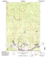
1996 Map of Thunderbolt Creek
USGS Topo · Published 1998About this map
The Continental Divide Scenic Trail snakes along the high ridges of the Powell Co Jefferson Co line, marking a landscape defined by sharp elevation changes and mineral wealth. This mid-1990s survey of the Helena National Forest and Deerlodge National Forest borderlands reveals an area deeply carved by waterways like the Little Blackfoot River and the Boulder River. Evidence of historical and active extraction is prominent, notably at the Saratoga Mine and numerous unnamed Prospect sites scattered throughout Alta Gulch and Boyle Gulch. The terrain is punctuated by significant peaks including Thunderbolt Mountain and Electric Peak, which overlook high-altitude water bodies such as Cottonwood Lake and Cliff Lake. The map illustrates a remote wilderness where the legacy of mining intersects with modern recreational trail systems.
Find a feature on this map
31 named features on this map. Tap any name to fly to it.
Don’t see what you’re looking for? This feature index may not catch every label — zoom into the map to look around manually.
Map Details
Editions of this 1996 Thunderbolt Creek Map
This is the sole edition of this map. No revisions or reprints were ever made.
Other maps of this area

1889 · Helena
USGS Topo · 1:250,000

1893 · Helena
USGS Topo · 1:250,000

1899 · Boulder
USGS Topo · 1:125,000

1899 · Helena
USGS Topo · 1:250,000

1903 · Helena
USGS Topo · 1:250,000

1947 · Butte
USGS Topo · 1:250,000

1954 · Elk Park
USGS Topo · 1:62,500

1954 · Basin
USGS Topo · 1:62,500

1958 · Butte
USGS Topo · 1:250,000

1959 · Butte North
USGS Topo · 1:62,500