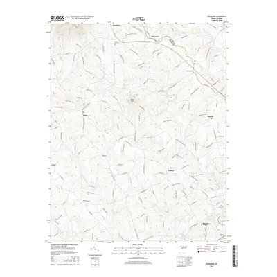
2016 Map of Thurmond
USGS Topo · Published 2016About this map
Doughton and Thurmond anchor the northern landscape of this Wilkes and Surry County borderland, where the topography transitions from the high elevations near Wells Knob toward the southern drainage of Elkin Creek. The map documents a dense network of early transportation routes and rural settlements, including Austin, Benham, and Lomax. A notable piece of historical infrastructure is the Old Railroad Grade Rd, which traces a path through the northern hills, hinting at the area's earlier timber or transit economy. The land is heavily partitioned by small waterways such as Grassy Fork and Little Elkin Creek, with Carter Falls marking a significant hydrological feature in the southeast. For genealogists, the map identifies several local landmarks for burial research, including Roaring Gap Cem and Knobs Cem, situated among the winding mountain valleys.
Find a feature on this map
131 named features on this map. Tap any name to fly to it.
Don’t see what you’re looking for? This feature index may not catch every label — zoom into the map to look around manually.
Map Details
Editions of this 2016 Thurmond Map
This is the sole edition of this map. No revisions or reprints were ever made.
Other maps of this area

1889 · Wilkesboro
USGS Topo · 1:125,000

1891 · Wilkesboro
USGS Topo · 1:125,000

1891 · Yadkinville
USGS Topo · 1:125,000

1893 · Yadkinville
USGS Topo · 1:125,000

1953 · Winston-Salem
USGS Topo · 1:250,000

1955 · Winston-Salem
USGS Topo · 1:250,000

1962 · Winston-Salem
USGS Topo · 1:250,000

1966 · Roaring River
USGS Topo · 1:24,000
1968 · Glade Valley
USGS Topo · 1:24,000
1968 · Traphill
USGS Topo · 1:24,000