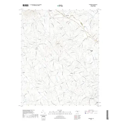
2019 Map of Thurmond
USGS Topo · Published 2019About this map
The boundary between Surry Co and Wilkes Co cuts through the center of this map, dividing a landscape defined by its complex network of creek drainage and ridge-top settlements. In the north, the S Fork Mitchell River flows near the crossroads of Thurmond and Doughton, while the southern reaches are dominated by the winding path of Elkin Cr. The terrain rises to its peak at Wells Knob, which overlooks a patchwork of local thoroughfares including Old Railroad Grade Rd and Thurmond Post Office Rd. Scattered rural communities like Austin, Benham, and Lomax are connected by numerous family-named roads, indicating a deeply rooted agricultural and residential pattern. For genealogists, the presence of the Roaring Gap Cem and State Road Cem provides specific points for family history research in this foothills region.
Find a feature on this map
132 named features on this map. Tap any name to fly to it.
Don’t see what you’re looking for? This feature index may not catch every label — zoom into the map to look around manually.
Map Details
Editions of this 2019 Thurmond Map
This is the sole edition of this map. No revisions or reprints were ever made.
Other maps of this area

1889 · Wilkesboro
USGS Topo · 1:125,000

1891 · Wilkesboro
USGS Topo · 1:125,000

1891 · Yadkinville
USGS Topo · 1:125,000

1893 · Yadkinville
USGS Topo · 1:125,000

1953 · Winston-Salem
USGS Topo · 1:250,000

1955 · Winston-Salem
USGS Topo · 1:250,000

1962 · Winston-Salem
USGS Topo · 1:250,000

1966 · Roaring River
USGS Topo · 1:24,000
1968 · Glade Valley
USGS Topo · 1:24,000
1968 · Traphill
USGS Topo · 1:24,000