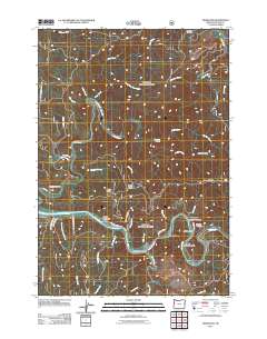
2011 Map of Tidewater
USGS Topo · Published 2011About this map
The Alsea River meanders through this landscape, defining the residential and commercial layout of communities like Alsea Riviera and Tidewater. This portion of the central Oregon Coast Range reveals a shift from the low-lying riverfront developments to the high, forested terrain of Butler Ridge and Boulder Ridge. Along the riverbanks, the Tidewater Post Office and Tidewater Cemetery serve as local landmarks for the small settlements of Little Albany, Little Switzerland, and Westwood Village. To the north, the land becomes dominated by the complex drainage of Drift Creek and its many tributaries, including Slickrock Creek and Trout Creek. These remote forested areas are marked by basic hiker infrastructure such as the Fivemile Shelter and Threemile Shelter, indicating the intersection of timber-producing land and recreational use in the early 21st century.
Find a feature on this map
47 named features on this map. Tap any name to fly to it.
Don’t see what you’re looking for? This feature index may not catch every label — zoom into the map to look around manually.
Map Details
Editions of this 2011 Tidewater Map
This is the sole edition of this map. No revisions or reprints were ever made.
Other maps of this area

1922 · Waldport
USGS Topo · 1:62,500

1942 · Waldport
USGS Topo · 1:62,500

1942 · Yaquina
USGS Topo · 1:62,500

1942 · Tidewater
USGS Topo · 1:62,500

1942 · Toledo
USGS Topo · 1:62,500

1953 · Salem
USGS Topo · 1:250,000

1954 · Salem
USGS Topo · 1:250,000

1956 · Tidewater
USGS Topo · 1:62,500

1956 · Waldport
USGS Topo · 1:62,500

1957 · Yaquina
USGS Topo · 1:62,500