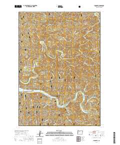
2020 Map of Tidewater
USGS Topo · Published 2020About this map
The Alsea River defines the southern landscape of this coastal Oregon region, where the tidal influence meets the foothills of the Siuslaw National Forest. The settlement of Tidewater serves as a local hub, situated near the Tidewater Cem and the distinctive bend of the river at Bain Slough. To the west, Little Albany and Barclay Meadows mark the narrow habitable corridors between the steep ridgelines of the Coast Range.
Find a feature on this map
46 named features on this map. Tap any name to fly to it.
Don’t see what you’re looking for? This feature index may not catch every label — zoom into the map to look around manually.
Map Details
Editions of this 2020 Tidewater Map
This is the sole edition of this map. No revisions or reprints were ever made.
Other maps of this area

1922 · Waldport
USGS Topo · 1:62,500

1942 · Waldport
USGS Topo · 1:62,500

1942 · Yaquina
USGS Topo · 1:62,500

1942 · Tidewater
USGS Topo · 1:62,500

1942 · Toledo
USGS Topo · 1:62,500

1953 · Salem
USGS Topo · 1:250,000

1954 · Salem
USGS Topo · 1:250,000

1956 · Tidewater
USGS Topo · 1:62,500

1956 · Waldport
USGS Topo · 1:62,500

1957 · Yaquina
USGS Topo · 1:62,500