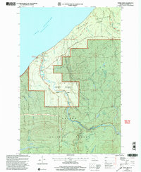
1999 Map of Tiebel Creek
USGS Topo · Published 2004About this map
The Presque Isle River carves a dramatic path through the western edge of the Porcupine Mountains State Park before emptying into the cold waters of Lake Superior. This late-twentieth-century landscape is defined by its water features, specifically a dense concentration of cascades near the coast including Manabezho Falls, Manido Falls, and Nawadaha Falls. Further south, the river winds through the Ottawa National Forest, where additional named drops like Lepisto Falls and Nokomis Falls mark the descent toward the lake. The topography is rugged, shaped by the Porcupine Mountains and numerous tributaries such as Tiebel Creek and Speaker Creek. Human presence is minimal, largely confined to the Presque Isle Campground and the South Boundary Road, reflecting a region dedicated to conservation and the preservation of its waterfalls.
Find a feature on this map
37 named features on this map. Tap any name to fly to it.
Don’t see what you’re looking for? This feature index may not catch every label — zoom into the map to look around manually.
Map Details
Editions of this 1999 Tiebel Creek Map
This is the sole edition of this map. No revisions or reprints were ever made.
Other maps of this area

1953 · Ashland
USGS Topo · 1:250,000

1956 · Carp River
USGS Topo · 1:62,500

1956 · North Ironwood
USGS Topo · 1:62,500

1956 · Thomaston
USGS Topo · 1:62,500

1958 · Ashland
USGS Topo · 1:250,000

1958 · Iron River
USGS Topo · 1:250,000

1960 · Iron River
USGS Topo · 1:250,000

1961 · Iron River
USGS Topo · 1:250,000

1967 · Iron River
USGS Topo · 1:250,000

1979 · Ontonagon
USGS Topo · 1:100,000