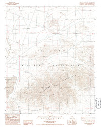
1986 Map of Tiefort Mountains
USGS Topo · Published 1986About this map
Fort Irwin Military Reservation dominates this mid-1980s landscape, illustrating the specialized infrastructure of a high-desert training installation. The rugged topography of the Tiefort Mountains serves as a natural backdrop for various defense installations, including a Radio Facility and a Radio Artillery Facility. Transport and logistics are central to the area's layout, with Bicycle Lake Road and a designated Landing Strip providing essential access. This period represents a mature stage of the reservation's development, where the land's natural features were systematically integrated with military communication and training needs. The presence of several Gravel Pits suggests local material extraction to support the maintenance of the base's road and facility networks.
Find a feature on this map
9 named features on this map. Tap any name to fly to it.
Don’t see what you’re looking for? This feature index may not catch every label — zoom into the map to look around manually.
Map Details
Editions of this 1986 Tiefort Mountains Map
2 editions found
Other maps of this area

1933 · Avawatz Mountains
USGS Topo · 1:250,000

1947 · Trona
USGS Topo · 1:250,000

1948 · Red Pass Lake
USGS Topo · 1:62,500

1948 · Trona
USGS Topo · 1:250,000

1948 · Alvord Mountain
USGS Topo · 1:62,500

1948 · Cave Mountain
USGS Topo · 1:62,500

1948 · Tiefort Mountains
USGS Topo · 1:62,500

1951 · Tiefort Mountains
USGS Topo · 1:62,500

1951 · Cave Mountain
USGS Topo · 1:62,500

1951 · Alvord Mountain
USGS Topo · 1:62,500