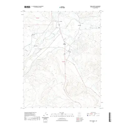
2020 Map of Tierra Amarilla
USGS Topo · Published 2020About this map
Tierra Amarilla, the historic seat of Rio Arriba County, sits at the center of this 2020 landscape where traditional irrigation and high-altitude water systems define the geography. The Rio Arriba County Courthouse serves as a central landmark for a cluster of traditional settlements including La Puente, Los Ojos, and Plaza Blanca. The distribution of these villages along the Rio Chama and the Rio Brazos reflects a long-standing reliance on river-fed agriculture, notably illustrated by the Tierra Amarilla Community Ditch and the Rito de Tierra Amarilla. The surrounding terrain transitions from the riparian corridors of the western preserves, such as Ft Heron Preserve, toward the more elevated landscapes near Ensenada Airport. This survey provides a precise modern record of the roads and watercourses that have shaped this community for generations.
Find a feature on this map
33 named features on this map. Tap any name to fly to it.
Don’t see what you’re looking for? This feature index may not catch every label — zoom into the map to look around manually.
Map Details
Editions of this 2020 Tierra Amarilla Map
This is the sole edition of this map. No revisions or reprints were ever made.
Other maps of this area

1918 · Tusas
USGS Topo · 1:125,000

1954 · Aztec
USGS Topo · 1:250,000

1955 · Chama
USGS Topo · 1:62,500

1955 · Cebolla
USGS Topo · 1:62,500

1955 · Brazos Peak
USGS Topo · 1:62,500

1955 · Tierra Amarilla
USGS Topo · 1:62,500

1958 · Aztec
USGS Topo · 1:250,000

1962 · Aztec
USGS Topo · 1:250,000

1965 · Aztec
USGS Topo · 1:250,000

1981 · Chama
USGS Topo · 1:100,000