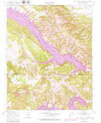
1949 Map of Tierra Redonda Mountain
USGS Topo · Published 1979About this map
San Antonio Reservoir dominates the landscape along the San Antonio River, its purple-tinted shoreline revisions reflecting changes in water levels and land use through the mid-20th century. This area, straddling the Monterey and San Luis Obispo county line, captures a transition from traditional valley agriculture to significant water management infrastructure. The presence of both the San Antonio Dam and a portion of the Nacimiento Res to the south underscores the era's focus on regional flood control and irrigation. Steep canyons like Buttle Canyon and Kemp Canyon feed into the valleys, while the prominent Tierra Redonda Mountain and the landmark Bee Rock define the local topography. For those studying the evolution of Hames Valley or Harris Valley, the map details the early roads and drainage patterns that preceded more intensive modern development.
Find a feature on this map
19 named features on this map. Tap any name to fly to it.
Don’t see what you’re looking for? This feature index may not catch every label — zoom into the map to look around manually.
Map Details
Editions of this 1949 Tierra Redonda Mountain Map
4 editions found
Other maps of this area

1919 · Bryson
USGS Topo · 1:62,500

1919 · Bradley
USGS Topo · 1:62,500

1919 · Adelaida
USGS Topo · 1:62,500

1919 · San Simeon
USGS Topo · 1:62,500

1932 · Adelaida
USGS Topo · 1:62,500

1937 · San Simeon
USGS Topo · 1:62,500

1941 · Bradley
USGS Topo · 1:62,500

1941 · Bryson
USGS Topo · 1:62,500

1942 · Adelaida
USGS Topo · 1:62,500

1942 · Bryson
USGS Topo · 1:62,500