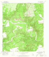
1969 Map of Tige Canyon
USGS Topo · Published 1972About this map
Double Mountain Fork Brazos River snakes through the center of this 1969 survey, where the rugged breaks of the Texas Rolling Plains meet the industrial footprint of West Texas petroleum exploration. The landscape is defined by deep incisions like Tige Canyon and Addie Canyon, which reveal the complex drainage systems feeding the river. This era of the late 1960s shows a terrain heavily marked by rural activity, with numerous Oil Wells scattered across the ridges and flats near Devils Backbone. The convergence of Fisher, Kent, and Stonewall counties is meticulously noted, highlighting the Indefinite Boundary that once divided these cattle and oil-producing districts. From the winding course of Rough Creek to the secluded Longhorn Valley, the map provides a precise account of the land's surface before decades of subsequent development and environmental change.
Find a feature on this map
21 named features on this map. Tap any name to fly to it.
Don’t see what you’re looking for? This feature index may not catch every label — zoom into the map to look around manually.
Map Details
Editions of this 1969 Tige Canyon Map
This is the sole edition of this map. No revisions or reprints were ever made.
Other maps of this area

1893 · Roby
USGS Topo · 1:125,000

1926 · Snyder 1-a
USGS Topo · 1:48,000

1926 · Roby 2-b
USGS Topo · 1:48,000

1931 · Rotan
USGS Topo · 1:62,500

1932 · Camp Springs
USGS Topo · 1:62,500

1954 · Lubbock
USGS Topo · 1:250,000

1954 · Big Spring
USGS Topo · 1:250,000

1958 · Big Spring
USGS Topo · 1:250,000

1968 · Double Mountains
USGS Topo · 1:24,000
1969 · White Canyon
USGS Topo · 1:24,000