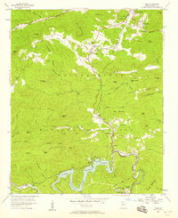
1957 Map of Tiger
USGS Topo · Published 1958About this map
Tiger and the surrounding peaks of the Chattahoochee National Forest are captured here in the late 1950s, a period of transition for this mountain corridor. The Tallulah Falls railroad line winds through the terrain, passing over the Wiley Trestle and connecting settlements like Wiley and Lakemont. The landscape is dominated by the steep ridges of Tiger Mountain and Stonewall Ridge, while the southern reaches show the waters of Lake Rabun and the Tallulah Falls Powerplant. Local genealogy is well-preserved through family-named landmarks such as Crukleton Ridge and several rural burial grounds including Bethel Cem and Jameson Cem. Cultural markers of the era are also present, from the Drive-in Theater near Tiger to the Athens YMCA Camp near the Tallulah River.
Find a feature on this map
76 named features on this map. Tap any name to fly to it.
Don’t see what you’re looking for? This feature index may not catch every label — zoom into the map to look around manually.
Map Details
Editions of this 1957 Tiger Map
4 editions found
Other maps of this area

1886 · Dahlonega
USGS Topo · 1:125,000

1886 · Walhalla
USGS Topo · 1:125,000

1892 · Dahlonega
USGS Topo · 1:125,000

1892 · Walhalla
USGS Topo · 1:125,000

1896 · Walhalla
USGS Topo · 1:125,000

1896 · Dahlonega
USGS Topo · 1:125,000

1903 · Dahlonega
USGS Topo · 1:125,000

1935 · Dillard
USGS Topo · 1:24,000

1935 · Rabun Bald
USGS Topo · 1:24,000

1935 · Hightower Bald
USGS Topo · 1:24,000