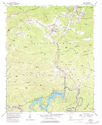
1957 Map of Tiger
USGS Topo · Published 1984About this map
Tiger sits at the heart of this North Georgia mountain landscape, where the ridges of the Chattahoochee National Forest meet the controlled waters of the Tallulah River. This mid-century survey captures a transition in local life, documenting traditional mountain institutions alongside modern leisure developments. Small community hubs like Wiley and Lakemont are anchored by landmarks such as Lakemont Sch and Joy Ch, while the presence of the Drive-in Theater near Tiger and the Athens YMCA Camp near the Tallulah Falls Powerplant reflects the area's growing role as a recreational destination.
Find a feature on this map
70 named features on this map. Tap any name to fly to it.
Don’t see what you’re looking for? This feature index may not catch every label — zoom into the map to look around manually.
Map Details
Editions of this 1957 Tiger Map
4 editions found
Other maps of this area

1886 · Dahlonega
USGS Topo · 1:125,000

1886 · Walhalla
USGS Topo · 1:125,000

1892 · Dahlonega
USGS Topo · 1:125,000

1892 · Walhalla
USGS Topo · 1:125,000

1896 · Walhalla
USGS Topo · 1:125,000

1896 · Dahlonega
USGS Topo · 1:125,000

1903 · Dahlonega
USGS Topo · 1:125,000

1935 · Dillard
USGS Topo · 1:24,000

1935 · Rabun Bald
USGS Topo · 1:24,000

1935 · Hightower Bald
USGS Topo · 1:24,000