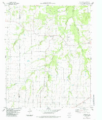
1984 Map of Tigertown
USGS Topo · Published 1985About this map
Tigertown serves as a focal point for this agrarian landscape on the border of Fannin Co and Lamar Co, Texas. The map illustrates a region defined by an intricate network of waterways, including the extensive branching of Sanders Creek and its many tributaries like Bergner Creek and the West Fork Middle Sanders Creek. These creeks carve through the terrain, influencing the placement of early settlements and rural infrastructure. Small community centers such as Forest Hill and Maxey are visible, anchored by local landmarks like the West Lamar Sch and Cottonwood Cem. The presence of several family-named water bodies, such as Holt Creek and Collins Creek, suggests a history of long-standing landholdings. This 1980s-era topographic study provides a clear view of the rural road network and water management features, including a Water Tank near Tigertown, that supported these Northeast Texas communities during a period of steady agricultural continuity.
Find a feature on this map
19 named features on this map. Tap any name to fly to it.
Don’t see what you’re looking for? This feature index may not catch every label — zoom into the map to look around manually.
Map Details
Editions of this 1984 Tigertown Map
This is the sole edition of this map. No revisions or reprints were ever made.
Other maps of this area

1903 · Paris
USGS Topo · 1:125,000

1947 · Honey Grove
USGS Topo · 1:62,500

1948 · Grant
USGS Topo · 1:62,500

1948 · Paris
USGS Topo · 1:62,500

1948 · Direct
USGS Topo · 1:62,500

1949 · Direct
USGS Topo · 1:62,500

1949 · Honey Grove
USGS Topo · 1:62,500

1949 · Grant
USGS Topo · 1:62,500

1949 · Paris
USGS Topo · 1:62,500

1953 · Texarkana
USGS Topo · 1:250,000