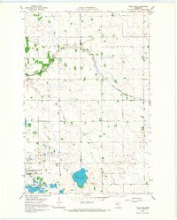
1966 Map of Tilde Lake
USGS Topo · Published 1967About this map
The landscape where Clay and Becker counties meet is defined by a complex network of glacial wetlands and agricultural engineering. In the mid-1960s, this area was undergoing significant hydrologic management, evidenced by the prominent Ditch No 8 and Ditch No 13 that channel water across the prairie flats. The Goose Prairie State Wildlife Management Area anchors the southwestern corner of the map, preserving a portion of the native marshland adjacent to Tilde Lake. The rural social fabric of the era is marked by the Atlanta Ch and a local Townhall, which served the dispersed farming communities in Walworth and Atlanta townships. The South Branch Wild Rice River meanders through the northern sections, its natural course contrasting with the straight lines of the surveyor’s township and range grid.
Find a feature on this map
16 named features on this map. Tap any name to fly to it.
Don’t see what you’re looking for? This feature index may not catch every label — zoom into the map to look around manually.
Map Details
Editions of this 1966 Tilde Lake Map
This is the sole edition of this map. No revisions or reprints were ever made.
Other maps of this area

1918 · Flom
USGS Topo · 1:62,500

1918 · Ulen
USGS Topo · 1:62,500

1919 · Hawley
USGS Topo · 1:62,500

1952 · Grand Forks
USGS Topo · 1:250,000

1953 · Fargo
USGS Topo · 1:250,000

1956 · Fargo
USGS Topo · 1:250,000

1956 · Grand Forks
USGS Topo · 1:250,000

1965 · Syre
USGS Topo · 1:24,000

1966 · Flom
USGS Topo · 1:24,000

1966 · Grand Forks
USGS Topo · 1:250,000