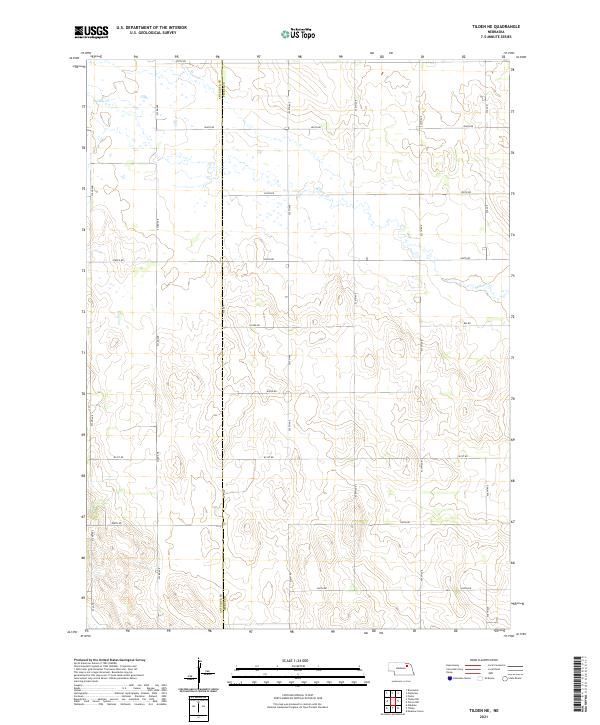
2021 Map of Tilden NE
USGS Topo · Published 2021About this map
Antelope Co and Pierce Co meet along a north-south boundary line on this 2021 survey, which illustrates the structured section-line grid of the northeastern Nebraska plains. The drainage of Willow Cr meanders from the northwest towards the east, cutting a winding path across the otherwise geometric division of the landscape. This map is defined by its extensive network of section roads, including arterial routes like Pierce Rd, 857th Rd, and 850th Rd, which facilitate the region's agricultural layout. Researchers can trace the precise boundaries of townships t26n r5w and t25n r4w, revealing how land was partitioned across the county line. The topography is subtle, showing the gentle elevation changes typical of the prairie terrain north of the Elkhorn River valley.
Find a feature on this map
23 named features on this map. Tap any name to fly to it.
Don’t see what you’re looking for? This feature index may not catch every label — zoom into the map to look around manually.
Map Details
Editions of this 2021 Tilden NE Map
This is the sole edition of this map. No revisions or reprints were ever made.
Other maps of this area

1955 · Sioux City
USGS Topo · 1:250,000

1958 · Sioux City
USGS Topo · 1:250,000

1959 · Sioux City
USGS Topo · 1:250,000

1963 · Pierce NW
USGS Topo · 1:24,000
1963 · Oakdale
USGS Topo · 1:24,000

1963 · Plainview
USGS Topo · 1:24,000

1963 · Brunswick
USGS Topo · 1:24,000

1963 · Foster
USGS Topo · 1:24,000

1963 · Meadow Grove
USGS Topo · 1:24,000
1963 · Tilden NE
USGS Topo · 1:24,000