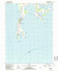
1988 Map of Tilghman
USGS Topo · Published 1988About this map
Tilghman Island anchors this coastal landscape where the Chesapeake Bay meets the Choptank River. The map reveals the intricate maritime geography of Talbot County, highlighting the way water defines local life through labels like Dogwood Harbor and the Knapps Narrows bridge. The settlements of Tilghman, Avalon, and Fairbank line the slender island, connected by Blackwalnut Road as it runs toward the tip at Blackwalnut Point.
Find a feature on this map
68 named features on this map. Tap any name to fly to it.
Don’t see what you’re looking for? This feature index may not catch every label — zoom into the map to look around manually.
Map Details
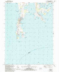
Editions of this 1988 Tilghman Map
2 editions found
Other maps of this area

1892 · Annapolis
USGS Topo · 1:62,500

1893 · Sharps Island
USGS Topo · 1:62,500

1898 · Choptank
USGS Topo · 1:125,000

1904 · St. Michaels
USGS Topo · 1:62,500

1904 · Annapolis
USGS Topo · 1:62,500

1904 · Sharps Island
USGS Topo · 1:62,500

1904 · Oxford
USGS Topo · 1:62,500

1908 · Choptank
USGS Topo · 1:125,000

1942 · Tilghman
USGS Topo · 1:31,680

1942 · Oxford
USGS Topo · 1:31,680