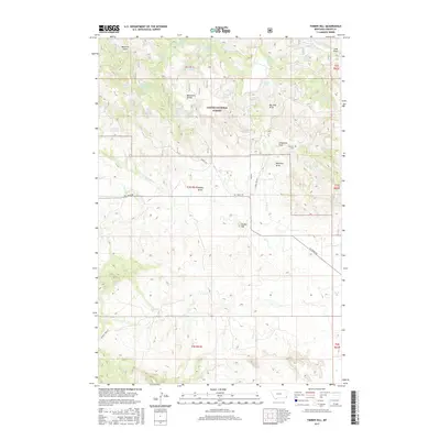
2017 Map of Timber Hill
USGS Topo · Published 2017About this map
Custer National Forest encompasses much of this eastern Montana landscape, where the high point of Timber Hill stands as a prominent landmark. The terrain is defined by a series of named drainages and topographic features like Belltower Divide and Long Pines, which have long shaped movement through this corner of Carter County. A significant concentration of natural springs, such as Ballinger Spring, Icebox Spring, and Big Tree Spring, provides vital water sources for the area's ranching economy, supplemented by man-made catchments like Pot Hole Reservoir and Brewer Reservoir. Local history is anchored at the Pioneer Cem located near Cheesman Draw. The map documents a network of forest service and secondary routes, including Chimney Rock Rd and Tie Creek Rd, which navigate the complex system of draws and gulches like Maverick Gulch and Blacktail Draw.
Find a feature on this map
47 named features on this map. Tap any name to fly to it.
Don’t see what you’re looking for? This feature index may not catch every label — zoom into the map to look around manually.
Map Details
Editions of this 2017 Timber Hill Map
This is the sole edition of this map. No revisions or reprints were ever made.
Other maps of this area

1954 · Ekalaka
USGS Topo · 1:250,000

1956 · Ekalaka
USGS Topo · 1:250,000

1958 · Ekalaka
USGS Topo · 1:250,000

1965 · Ekalaka
USGS Topo · 1:250,000
1980 · Belltower
USGS Topo · 1:24,000
1980 · Capitol Rock
USGS Topo · 1:24,000
1980 · Rustler Divide
USGS Topo · 1:24,000
1980 · Belltower Butte
USGS Topo · 1:24,000
1980 · Capitol NW
USGS Topo · 1:24,000
1980 · Lone Tree Creek
USGS Topo · 1:24,000