
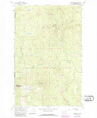
1967 Map of Timber Mtn.
USGS Topo · Published 1971About this map
Timber Mtn dominates the central landscape of this northeast Washington region, which serves as a critical divide between the drainage of Ruby Creek and the southern headwaters. The 1960s terrain is defined by its industrial and conservation history, specifically within the Little Pend Oreille Nat Wildlife Refuge. Resource extraction is evident in the northern slopes, where the High Noon Mine and Triple H Mine are situated near the North Fork Lost Creek. A network of unpaved paths, including the Tacoma Divide Road and various Jeep Trails, provides access through the elevations of Granite Peak and across high meadows like Granite Meadows and Rufus Meadows. This survey illustrates the specialized land use of the era, balancing high-altitude mining operations with federal wildlife preservation along the Stevens and Pend Oreille county line.
Find a feature on this map
19 named features on this map. Tap any name to fly to it.
Don’t see what you’re looking for? This feature index may not catch every label — zoom into the map to look around manually.
Map Details
Editions of this 1967 Timber Mtn. Map
2 editions found
Other maps of this area

1927 · Chewelah
USGS Topo · 1:125,000

1929 · Colville
USGS Topo · 1:125,000

1930 · Chewelah
USGS Topo · 1:125,000

1933 · Colville
USGS Topo · 1:125,000

1934 · Metaline
USGS Topo · 1:125,000

1936 · Newport
USGS Topo · 1:96,000

1942 · Metaline
USGS Topo · 1:125,000

1942 · Newport
USGS Topo · 1:125,000

1958 · Sandpoint
USGS Topo · 1:250,000

1963 · Sandpoint
USGS Topo · 1:250,000