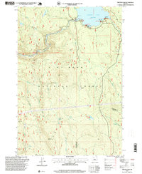
1997 Map of Timothy Lake
USGS Topo · Published 1999About this map
Timothy Lake dominates the upper portion of this quadrangle, serving as a focal point for recreation and resource management within the Mt Hood National Forest. Reaching an elevation of 3,227 feet at its spillway, the lake is flanked by infrastructure such as a Powerhouse and developed sites including Pine Point and Hood View. The landscape is defined by the steep drainage of the Oak Grove Fork Clackamas River, which receives numerous tributaries like Buck Creek and Anvil Creek. Industrial activity in this mountainous terrain is evidenced by several mineral extraction sites, including Alligator Quarry and the Stone Creek Gravel Pit. High-altitude routes, most notably the Pacific Crest National Scenic Trail and the Clackamas River Trail, provide passage through the dense forest, while the border between Clackamas and Wasco Counties cuts through the southeastern corner near Summit Lake.
Find a feature on this map
48 named features on this map. Tap any name to fly to it.
Don’t see what you’re looking for? This feature index may not catch every label — zoom into the map to look around manually.
Map Details
Editions of this 1997 Timothy Lake Map
This is the sole edition of this map. No revisions or reprints were ever made.
Other maps of this area

1924 · Mount Hood
USGS Topo · 1:125,000

1927 · Mount Hood
USGS Topo · 1:125,000

1927 · Mt. Jefferson
USGS Topo · 1:125,000

1930 · Mt. Jefferson
USGS Topo · 1:125,000

1953 · The Dalles
USGS Topo · 1:250,000

1955 · Bend
USGS Topo · 1:250,000

1956 · The Dalles
USGS Topo · 1:250,000

1956 · High Rock
USGS Topo · 1:62,500

1956 · Mt. Wilson
USGS Topo · 1:62,500

1957 · Bend
USGS Topo · 1:250,000